Wandelen in Zeeuws-Vlaanderen
temporary_not_available

€ 6,61 excl. VAT
-
In stock
Description
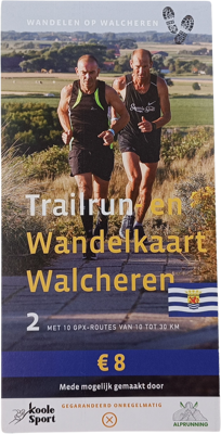
Discover the stunning Walcheren Peninsula with our exclusive trail running and hiking map, featuring 10 carefully selected GPX routes ranging from 6 to 66 kilometers. Whether you’re an avid trail runner or prefer a more leisurely pace, this map has something for everyone.
Features:
Varied distances: With routes from 6 to 66 kilometers, there’s a perfect distance for every adventurer, from short, relaxing walks to challenging long-distance trails.
Beautiful landscapes: Walcheren is known for its breathtaking nature, picturesque villages, and historic landmarks. Each route lets you enjoy the most beautiful spots on the peninsula.
GPX routes: The included GPX files make it easy to find your way. Load the routes onto your GPS device or smartphone and follow the suggested paths with confidence.
Detailed map: The map provides detailed information about the terrain, elevation changes, and interesting points along the routes, so you can be well-prepared.
Contents:
10 Unique GPX routes: From coastal paths along the North Sea to forests and polder landscapes, each route offers a unique experience.
Why choose our Walcheren Trail Running and Hiking Map?
Our map is designed by local experts who know the region inside out. With attention to detail and a love for nature, they have selected the most beautiful and interesting routes. Whether you’re seeking the tranquility of a solitary walk along the coast or the adrenaline of a challenging trail run through the woods, this map provides the perfect guide to experience Walcheren at its best.
Order now and start your adventure!